Sandfellsjökull: Glacier Mapping Expedition — A Unique Journey into Iceland’s Ice
If you’re looking for an experience that combines adventure, science, and stunning scenery, the Sandfellsjökull Glacier Mapping Expedition offers just that. Based in Iceland’s Southern Region, this full-day tour (roughly 10 hours) takes you on a journey into one of Iceland’s most captivating glaciers, Sandfellsjökull. Led by expert guides, you’ll not only witness incredible icy landscapes but also contribute to vital climate research as a Katla Geopark Civilian Scientist.
What makes this expedition stand out? First, it offers a rare chance to actively participate in scientific work—mapping the glacier’s surface and helping scientists understand climate change’s effects. Second, the scenery is genuinely breathtaking, with expansive views of icy crevasses, rugged volcanic terrain, and the surrounding glaciers. We appreciate that it’s a meaningful activity for those who love nature and want to leave a positive mark on the environment.
A potential consideration is that the tour requires participants to be in good physical condition because of the moderate hiking involved and variable weather conditions. It’s not suitable for young children, pregnant women, or anyone with mobility issues or heart problems. So, if you’re looking for a relaxed sightseeing trip, this might not be for you. But if you’re an active traveler eager to combine education with adventure, this tour will appeal.
This expedition is perfect for nature enthusiasts, environmental advocates, and curious travelers eager to explore Iceland’s glaciers in a way that’s both fun and impactful. It’s a rare opportunity to learn, contribute, and witness some of the most spectacular natural scenery Iceland has to offer.
Key Points
- Unique hands-on experience: Contribute directly to glacier mapping and climate research.
- Spectacular scenery: Expect stunning views of Sandfellsjökull, volcanic terrain, and icy landscapes.
- Expert guidance: Led by knowledgeable guides who provide both safety and scientific training.
- All-inclusive: Equipment, transportation, and certificates included.
- Physical readiness: Moderate activity level suitable for fit travelers.
- Limited group size: Ensures personalized attention and guidance.
👉 See our pick of the 16 Most Highly Rated Tours In Vik
Exploring the Sandfellsjökull Glacier Mapping Expedition
You can also read our reviews of more tours and experiences in Vik.
An Introduction to the Adventure
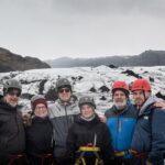
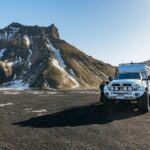
This isn’t your typical Iceland tour. The Sandfellsjökull Glacier Mapping Expedition is a full-day activity that blends adventure, science, and scenic beauty. The route begins with a round-trip 4×4 ride from the charming town of Hvolsvöllur, deep into the Southern Icelandic landscape. Once there, you’ll meet your guide—usually a local expert passionate about glaciers and climate change—and start your journey into the icy wilderness.
The goal: becoming a Civilian Scientist for a day by helping to map the glacier’s surface using specialized equipment. It’s a rare chance to get hands-on with glacier science, which is normally reserved for researchers or scientists working in labs. Here, you’ll learn how glaciers form, their importance in the global climate system, and how they’re changing over time.
What to Expect on the Day
The tour lasts around 10 hours, including travel time, so be prepared for a full-day commitment. You’ll start with an early departure from Hvolsvöllur, traveling in a comfortable 4×4 vehicle through Iceland’s rugged terrain. The journey itself is scenic, with views of volcanic formations, black sand plains, and distant glaciers.
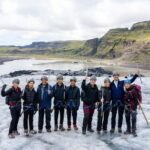
Once at Sandfellsjökull, your guide will provide a Citizen Scientist training session, explaining how to use mapping equipment and what data to collect. This training is straightforward but essential, ensuring everyone contributes meaningfully. Then, you’ll head out onto the glacier, wearing warm clothing, sturdy hiking shoes, rain gear, and waterproof cameras—all recommended to handle Iceland’s unpredictable weather.
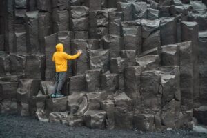
Throughout the day, expect to be actively involved—walking across uneven ice, possibly climbing gentle slopes, and working in a team to complete mapping tasks. The guides are attentive to safety and will adapt the schedule based on weather or glacier conditions.
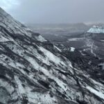
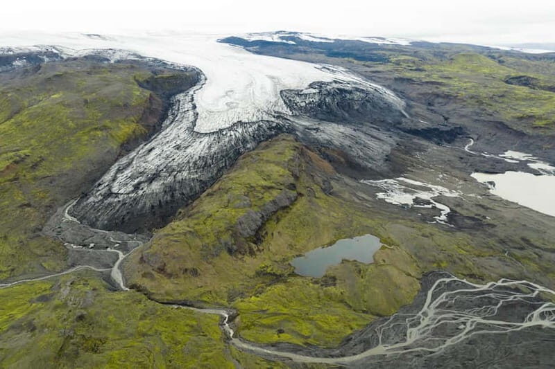
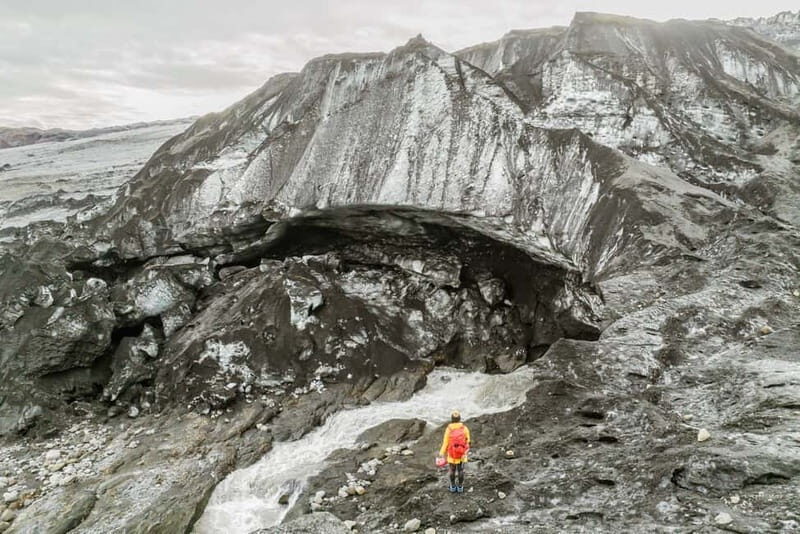
The Scenery and Scientific Contribution
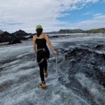
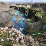
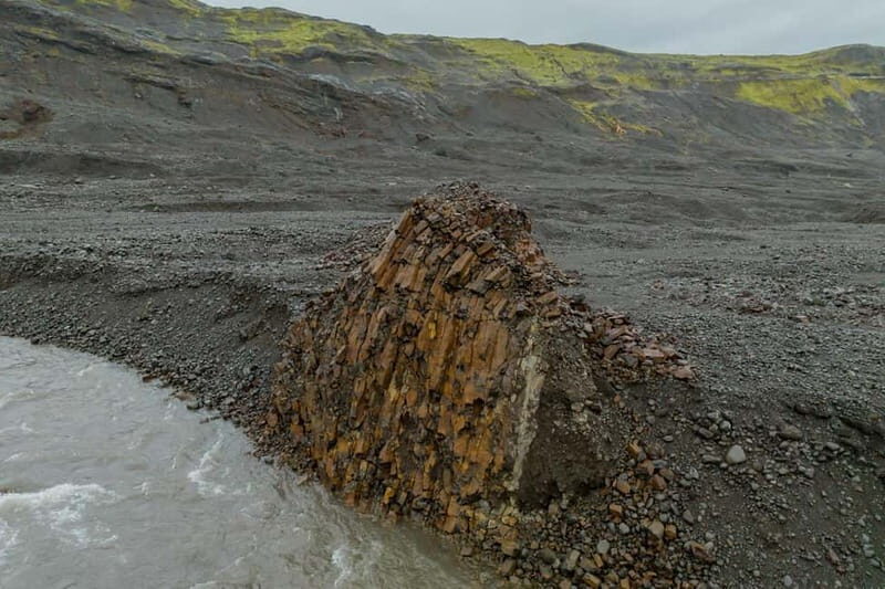
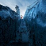
One of the highlights is the spectacular scenery. The glacier itself is a maze of icy fissures, with layers revealing the glacier’s history. The surrounding volcanic terrain adds a rugged backdrop, with black lava rock contrasting sharply against the white ice. As you work, you’ll be treated to sweeping vistas, perfect for photos or simply soaking in the stark beauty of Iceland’s ice.
We loved the way the guides explained how each data point contributes to understanding climate change. The feeling of actively helping gather scientific data creates a sense of purpose rarely found on typical sightseeing trips. Several reviewers noted that they left feeling both informed and inspired, with some saying, “It’s rare to do something so meaningful while traveling.”
More Great Tours NearbyPractical Details and Logistics
Transportation is included in the form of a round-trip 4×4 transfer from Hvolsvöllur, which ensures comfort while traversing Iceland’s often challenging roads. The included glacier and mapping equipment is state-of-the-art, and participants receive a Citizen Scientist Certificate from Katla Geopark, a nice keepsake and recognition of your contribution.
The tour is suitable for those in good physical condition due to the moderate exertion involved; hikers should be prepared for uneven terrain and variable weather. The group size is limited to preserve a personalized, safety-conscious environment.
Cost and Value
While the tour isn’t cheap, it offers considerable value for those interested in hands-on science and authentic experiences. For around 810 hours of total activity (including travel and training), you get expert guidance, specialized equipment, transportation, and a meaningful scientific role. Plus, the ongoing updates on the data collected allow you to see the impact of your efforts.
Who Will Enjoy This?
This expedition suits adventurous travelers aged 10 and above who are physically fit and eager to do more than just look at glaciers. It’s ideal for environmental enthusiasts, students, or anyone curious about climate change and wanting a deep, practical understanding of glaciers. It’s less suitable for those who prefer relaxed sightseeing, have mobility issues, or are not comfortable in cold, uneven environments.
Final Thoughts
The Sandfellsjökull Glacier Mapping Expedition offers a rare blend of adventure, education, and contribution. You’ll marvel at the beauty of Iceland’s glaciers, learn about their vital role in the climate system, and actively help scientists gather data that may inform future environmental policies. It’s a trip that leaves you with lasting memories—and perhaps even a feeling of having made a small but meaningful difference.
If you’re someone who loves outdoor activities, enjoys learning about nature, and wants a genuine, impactful experience in Iceland, this tour ticks all the boxes. It’s a fantastic choice for those looking to combine travel with purpose and are ready for a moderate physical challenge in return for some of the most stunning views the country has to offer.
Sandfellsjökull: Glacier Mapping Expedition
FAQ
Do I need special skills or experience?
No special skills are required, but you should be in good physical condition and comfortable walking on uneven, icy terrain. The guide provides training on the equipment, making it accessible for most active travelers.
Is the tour suitable for children?
Children under 10 years old are not recommended, mainly due to the physical requirements and safety considerations in cold environments.
What should I wear?
Bring warm clothing, hiking shoes, rain gear, water, and a waterproof camera. Layering is advised to adapt to changing weather conditions.
How long is the transportation?
Travel from Hvolsvöllur to Sandfellsjökull takes approximately 4×4 hours round-trip, depending on weather and road conditions.
Can I join if I’m not interested in scientific work?
This tour is designed around active participation, so if you prefer a purely sightseeing trip, this might not be the best fit.
Are meals included?
No, meals and drinks are not included, so plan to bring snacks and water for the day.
What if the weather is bad?
Weather can impact the itinerary, and safety is a priority. The guide may adjust or reschedule the activity if conditions are unsafe.
Will I get a certificate or proof of participation?
Yes, you’ll receive a Citizen Scientist Certificate from Katla Geopark, along with updates on how your data is being used.
In sum, the Sandfellsjökull Glacier Mapping Expedition is a compelling choice for travelers craving a meaningful adventure that combines scenic beauty, scientific contribution, and personal achievement. It’s best suited for active, curious souls eager to go beyond traditional sightseeing and make a genuine impact on understanding one of Iceland’s iconic glaciers.
You can check availability for your dates here: